
 Well that was a lot of fun!
I hope you enjoyed puzzling over these landscape shots from the new Crossley ID Raptor Guide as much as I did. It's great to see so many great American landscapes depicted in a birding guide. This guide for sure gets the "best background shots" award for any field guide. I'm still gawking (maybe even geeking out?) over all the great landscape shots.
But enough about me! Let's take a look at the seven shots again, and reveal their locations. Then we'll reveal the overall winner!
.jpg) |
| Birdscape #1 |
 |
| Birdscape #2 |
This was one of the most correctly guessed locations. Perhaps because it is one of the most visited hawkwatching and overall birding sites in the United States. 75% of all contestants gave the correct answer:
Cape May State Park hawkwatch and Bunker Pond area, from the lighthouse (map here).
 |
| Bing birdseye view of Cape May lighthouse, hawkwatch platform, and Bunker Pond. |
 |
| Birdscape #3 |
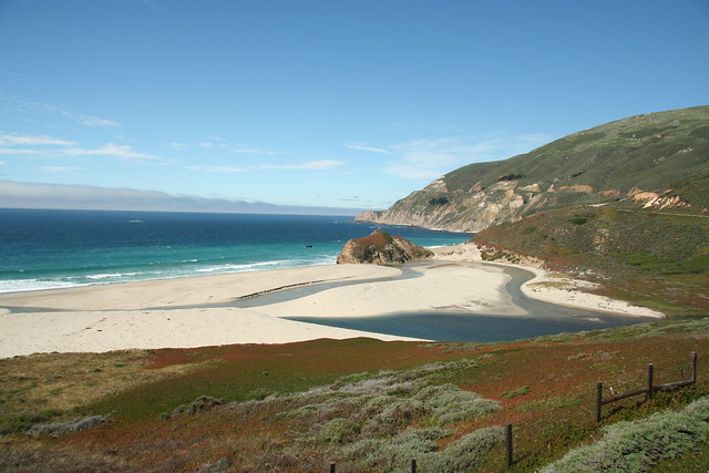
But where exactly is this? Doing a fly over of the Big Sur area with Google Earth and Bing I was able to locate it:
 |
| Mouth of the Little Sur River, Monterey, California |
BTW, this Crossley ID Raptors shot was better than any pic of the Little Sur River mouth that I could find online. I'm telling you, these landscape shots are practically Ansel Adamsishly good!
 |
| Birdscape #4 |
 |
| Birdscape #5 |
A walkway through perhaps a wetland with palm trees in the background. You might think there were a lot of places this might be in the American Southeast. 94% of our contestants correctly guessed a location in Florida, and a whopping 50% correctly identified it as the Anhinga Trail in Everglades National Park.
 |
| Birdscape #6 |
Rugged mountains, sparse vegetation. All but one contestant guessed somewhere in the western United States. Just over 50% named a site in the correct state--Arizona. From there, only 4 were able to name this as the lower part of Madera Canyon. Guess you have to have been there!
The fun thing is that with Google Earth, you can practically identify the exact point where this photo was taken:
 |
| Google Earth location for Crossley ID Raptors Guide shot of Madera Canyon |
It's on the road into the canyon, about 1.3 miles before the canyon mouth.
 |
| Location of Crossley ID Raptor Guide shot of Madera Canyon |
 |
| Birdscape #7 |
I'm not sure how anyone would have gotten that, but interestingly, 3 contestants actually guessed Merritt Island for Birdscape #2! Crazy!
Anyway, just for fun, I spent way too much time on Google Earth looking to see if I could actually find this exact spot on Merritt Island. It's a big place, but here were my clues--looking for a nice two-lane paved road out away from development that makes a strong bend. There actually didn't seem to be too many roads like that on Google Earth. When I could find a two-lane paved road I would follow it. Low and behold, I may have actually found this very tower (if it isn't a Crossley photoshop special!) up at the very northernmost part of the island on the Courtney Parkway where it makes a turn to the northwest just before it cuts back over to the mainland (see map here). Anyway, I couldn't find any better candidate on the island, so hopefully this is it!
 |
| Presumed Merritt Island vulture tower from the Crossley ID Raptor Guide. |
So that was fun. And as you look through the Crossley ID Raptor Guide, you may find yourself inspired to do some initial exploring on Google Earth to see how many other locations you can ID! Oh yeah, you can also use the book to help you ID birds of prey :-)
The Winner
Amazingly, one candidate was able to identify 6 of the 7 locations--all but this last one on Merritt Island. He was the only one to identify Mt. Lemmon, and the only one to narrow down the Big Sur location to the mouth of the Little Sur River. Congratulations to Tom Ford-Hutchinson from Irvine, California!
Close runner-ups, each identifying 5 locations (missing only Mt. Lemmon and Merritt Island) are Bill Etter and Patty Topp. Practically tied for second place was also Linda Widdop, who only nailed down 4 locations, but had the correct state for the other 3--the only contestant to correctly guess the state of all 7 locations. 3 other contestants correctly identified birdscape #s 2, 3, 4, 5. Congrats to all who played, and correctly identified at least one birdscape--I'm sure that represents some good birding time out and about the country! Hopefully this little game and the Crossley ID Raptor Guide will inspire you to go out and enjoy even more of our wonderful birdscapes!
Special thanks to Princeton Press and Richard Crossley for making this little game possible, and for providing a copy of the Crossley ID Raptor Guide for me to review, and one for our winner to enjoy!

I can't believe I guessed those locations in AZ correctly, props to Mike Lester for taking around the state!
ReplyDeleteWow! Going through these images just now, I only recognized Hawk Mountain... should have had Cape May and Mt. Lemmon from the landscape, but after a day of fieldwork, I'll be happy that I can still ID something.
ReplyDelete